

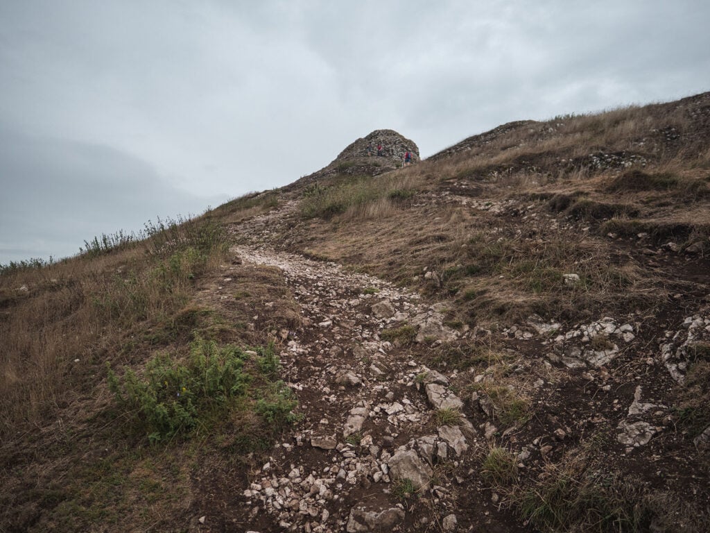
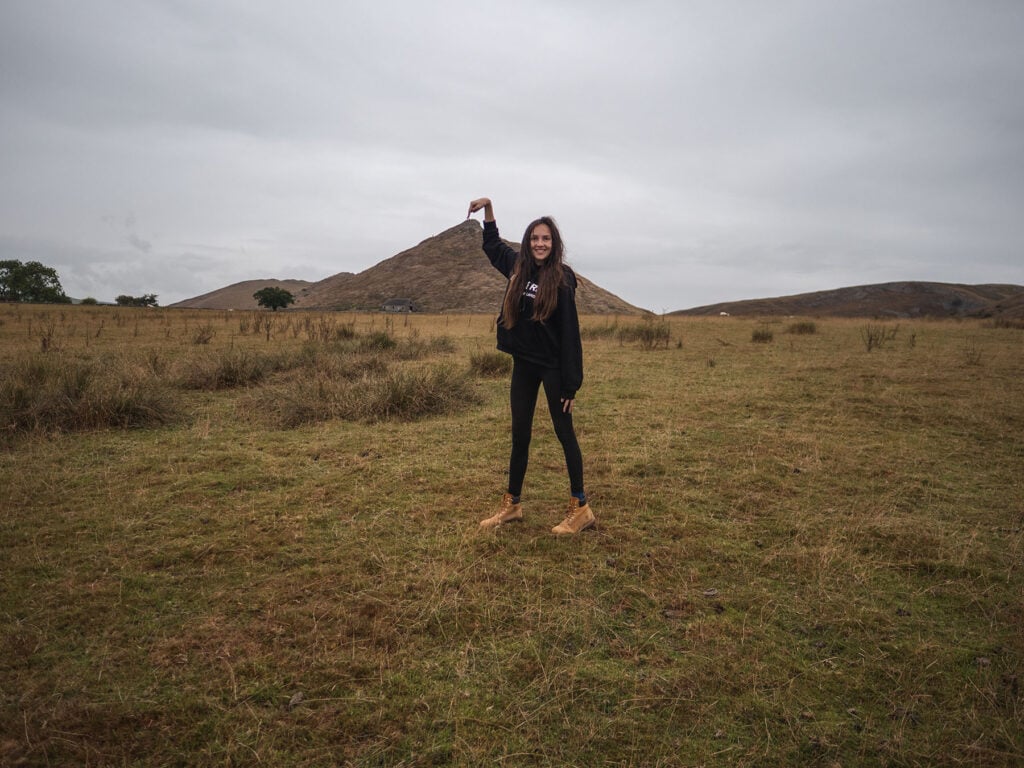
Chalky limestone crunched beneath my feet as I took another step closer to Thorpe Cloud’s elusive summit.
The incline had steepened rapidly and for the last stretch it appeared I would have to scramble in order to find myself perched on the mighty backbone of this mountain.
Splat. The sky had unleashed a torrent of water, making the protruding rocky outcrops slick beneath my feet.
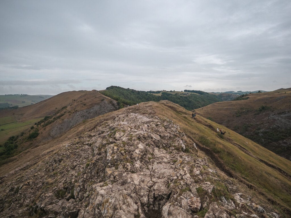
With a last burst of effort I found myself on the summit, a striking panorama of the Dove valley all around me.
Standing here on Thorpe cloud, an isolated limestone hill, I found myself mesmerised by the beauty of my surroundings. It was plain to see exactly why this climb is so popular with walkers in the Dove Valley.
In this guide I aim to tell you everything you need to know about climbing Thorpe Cloud.
You may also be interested in my other Dovedale guides on the famous Dovedale Stepping Stones which sit below Thorpe Cloud and the beautiful stone hamlet of Milldale.
Table of Contents
- Thorpe Cloud Quick Facts
- Thorpe Cloud’s Mysterious Double Sunset
- Why is it called Thorpe Cloud?
- How was Thorpe Cloud in the Peak District Formed?
- What’s It Like to Climb Thorpe Cloud?
- What Is The Summit of Thorpe Cloud Like?
- Is Thorpe Cloud Safe?
- Planning Your Visit to Thorpe Cloud in the Peak District
- Thorpe Cloud Packing list
- Thorpe Cloud Walks
- FAQs
- Thorpe Cloud Railway Station
- What has been Filmed at Thorpe Cloud?
- Food and Drinks Near Thorpe Cloud
- Holiday Cottages Near Thorpe Cloud
- Hotels & Hostels Near Thorpe Cloud
- Thorpe Cloud Camping
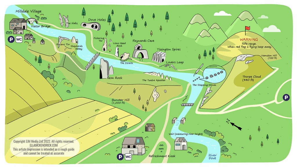
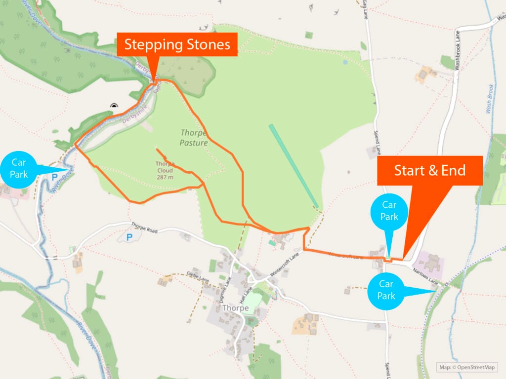
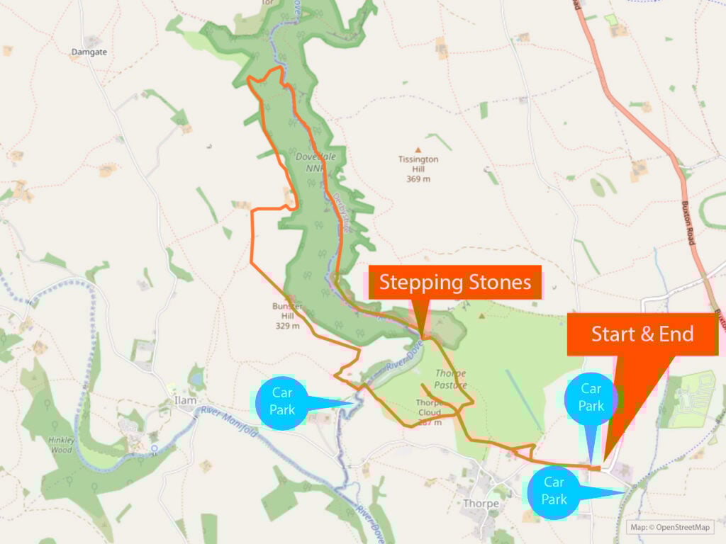
Thorpe Cloud Map
Thorpe Cloud Quick Facts
Elevation: 287 m (942 ft)
Prominence: 79 m (259 ft)
Coordinates: 53°03′22″N 1°46′34″W
Walk difficulty: Moderate
Shortest walk length (return): 1 hour
Operated by: National Trust
Dog-friendly: Yes
Child-friendly: Yes
Best time of year to visit: Spring or summer. Avoid periods of heavy rain when the path may be slippy
Best time of day to visit: To avoid crowds, visit early in the morning or late evening.
Entry costs: Free
Car park costs: Narlows Lane Thorpe: FREE. Dovedale Car Park £4.50 for up to 4 hours and £6 for all day. Machine only takes coins. Free for National Trust members
Opening times: 24/7
Food: Available at Dovedale Car Park kiosk or The Old Dog pub near Narlows Lane Car Park.
Top Tip: There’s no phone signal or internet so make sure you have offline maps downloaded on your phone before your walk
Thorpe Cloud’s Mysterious Double Sunset
There have been reports of a mysterious double sunset during the summer solstice week.
A double sunset is a rare astro-geographical phenomenon, in which the sun appears to set twice in the same evening from a specific viewing-point. Such phenomena may have been regarded as significant in prehistoric times.
Wikipedia
How see see Thorpe Clouds Double Sunset
Around the summer solstice and possibly some time after it, visit the top of nearby Lin Dale before sunset.
Watch as the sun sets on the summit of the hill, partially reappears from its steep northern slope and sets for a second and final time shortly afterwards.
How does it happen?
The apparent double sunset is due to the rotation of the Earth. As the sun sinks behind Thorpe Cloud the planet continues to rotate, allowing the sun to become briefly visible again.
Can I look directly at it?
Never look directly at the sun with the naked eye. Always use a solar filter or, at least, sunglasses.
Why is it called Thorpe Cloud?
The name Thorpe Cloud has a romantic ring to it. I almost expected to find out the name derived from the fact that the summit is frequently being shrouded in clouds. Alas, that is not the case.
Thorpe Cloud in old English means Hill [nearby an] Outlying Farmstead.
Thorpe was a Viking word for an outlying farmstead, one that probably relied on a larger settlement nearby for protection.
A few sources suggest a slightly different explanation: The Vikings most popular word for naming places was bær. In Old Norse, the viking language this word bær meant settlement or village. Thorpe is an Anglo-Saxon word deriving from Old Norse þorp.
All sources are in agreement that Cloud is a derivation of the Anglo-Saxon word “clud”, meaning a mass of stone, rock, boulder or hill.
The village of Thorpe was called Thorpe because it was a settlement and Thorpe meant outlying farmstead and Thorpe Cloud was so called because it was a hill next to the village of Thorpe.
How was Thorpe Cloud in the Peak District Formed?
Like much of Dovedale, Thorpe Cloud is comprised of limestone.
In fact there are two types of reef limestone in the Peak District. Reef limestone mud mounds (reef knolls) and apron reefs. Thorpe Cloud (and neighbouring Bunster Hill) are notable examples of mud mounds.
Mud mounds (also known as reef knolls) are landforms that are made up of a great pile of calcareous material. Millions of years ago reef knolls grew upwards as the sea floor sank, formed by organisms such as algae and bryozoa working harder and growing larger to try and grasp sunlight. As it grew upwards, this unique structure had enough strength provided by the skeletal matter of the dead organisms to enable it to withstand sea currents and in turn the brunt of erosion.
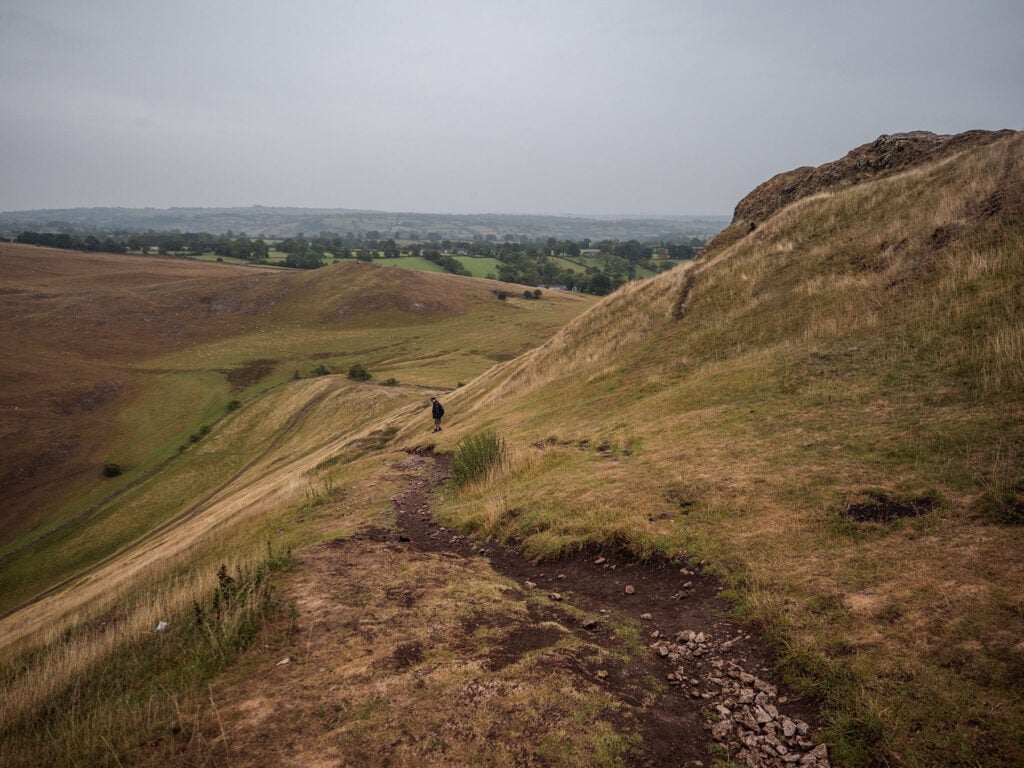
What’s It Like to Climb Thorpe Cloud?
Thorpe Cloud is a short but steep hike with a scramble at the top. There were plenty of families with small children enjoying the climb.
At first sight the climb was rather intimating. However, In reality It’s a surprisingly short and relatively easy hike for such an outstanding view. It only took about 20-30 minutes to reach the summit.
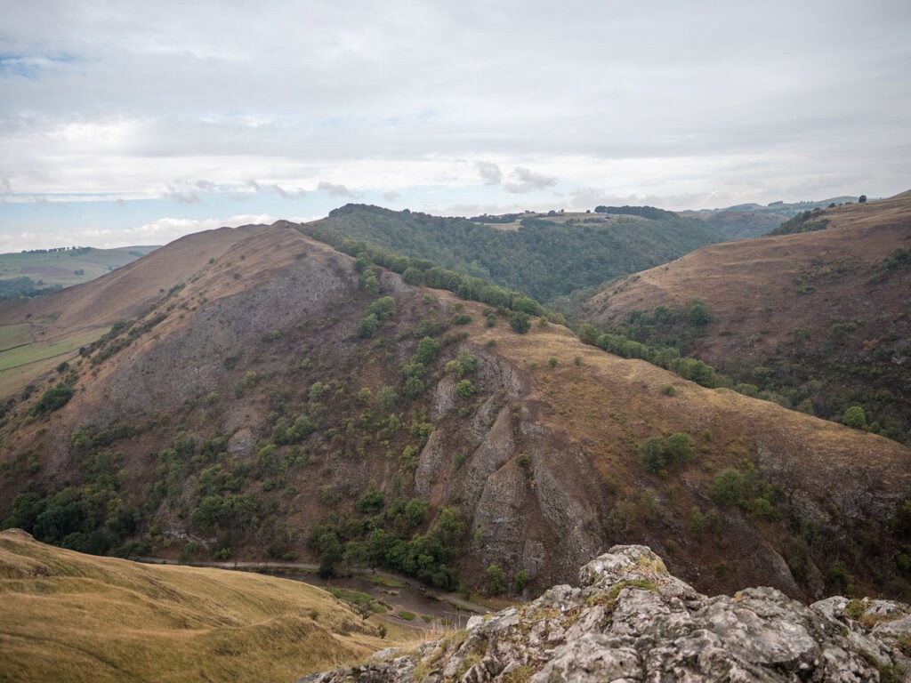
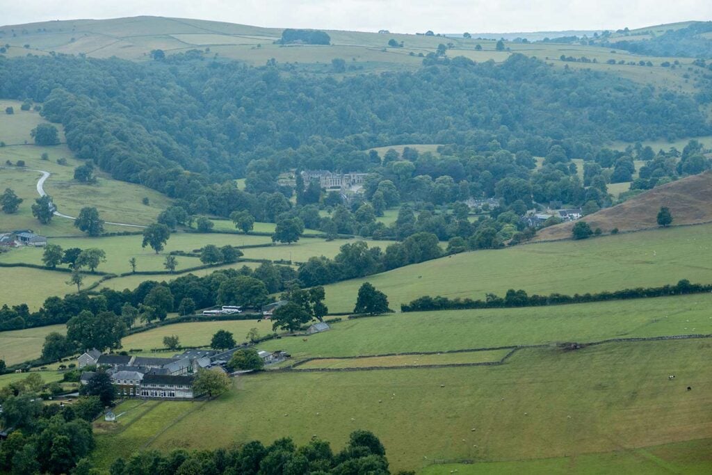
As you hike up you are rewarded with increasingly spectacular views of the majestic Bunster Hill on your left and beyond that the impressive Ilam Hall and to your right the quaint Lin Dale.
I would recommend wearing good walking boots with ankle support as well as avoiding days with bad weather unless you’re an experienced walker. It was raining heavily when I reached the summit which made it quite slippy coming back down.
There are a number of alternative routes with signs which advise you to take the recommended route due to erosion and risk of falling rocks.
See the section on Thorpe Cloud Safety for details of any reported accidents.
What Is The Summit of Thorpe Cloud Like?
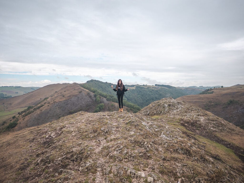
The summit of Thorpe Cloud is a long flat walkway of limestone bursting from through its grassy skin interspersed with tufts of moss.
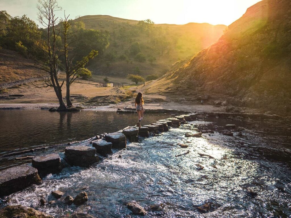
As you stand triumphantly on the summit you are greeted by outstanding panoramic views across Dovedale. If you venture cautiously along the ridge of the summit towards the far end, you can gaze down on the famous Dovedale Stepping Stones and watch the tiny dots of people walking across them.
Is Thorpe Cloud Safe?
Given the huge numbers of visitors to Thorpe Cloud in the Dovedale Valley, there are reassuringly few reported accidents and I couldn’t find any serious accidents.
Reported incidents on Thorpe Cloud
- Derby Mountain Rescue Team reported 71 callouts in 2021 across Derbyshire.
- In June 2021 A 73 year old man slipped and dislocated his knee when out walking with his wife.
- In January 2022 a woman suffered an ankle injury when out walking with her family up Thorpe Cloud.
- A middle-aged man had to be airlifted from the side of Thorpe Cloud in Derbyshire’s after suffering a heart attack.
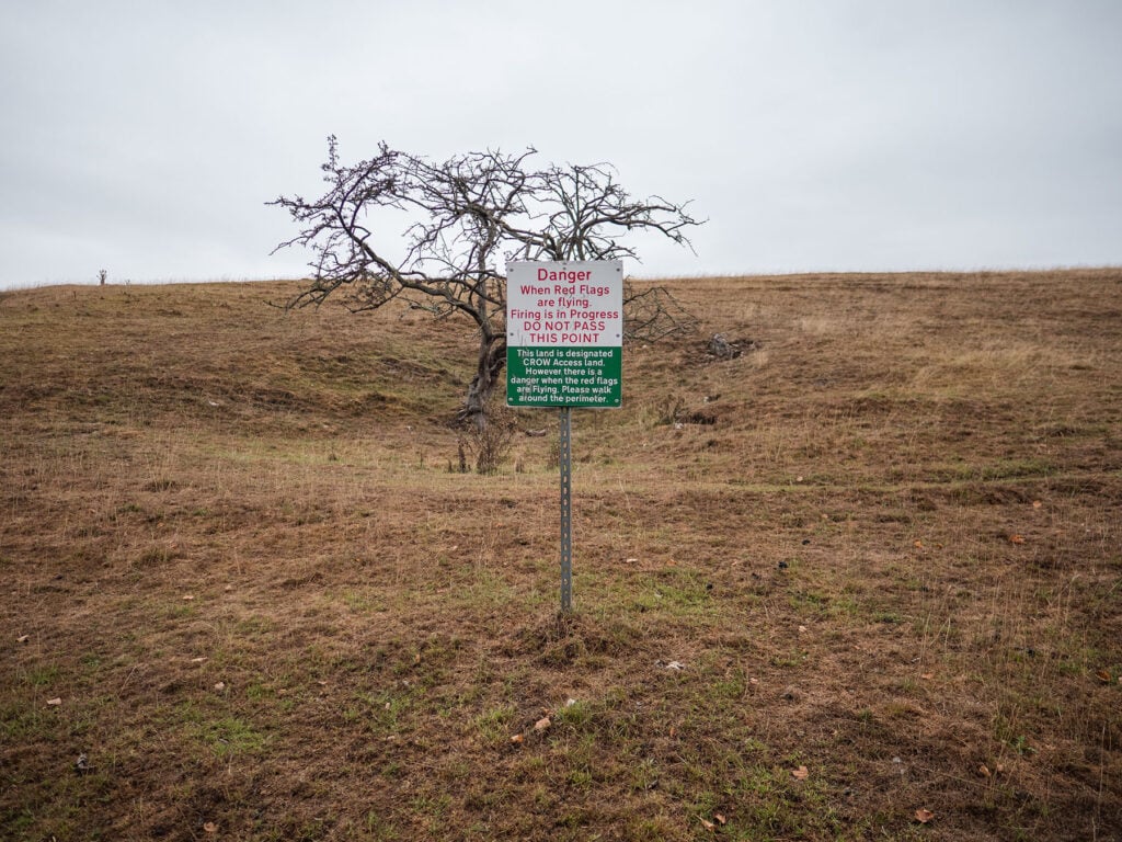
There is a Shooting Range on the East Side of Hamston Hill – there are clear warning signs and flags to keep you safe.
As with most walking and hiking activities the key is being properly prepared by doing your research beforehand, considering the weather and wearing and packing the appropriate gear. I’ve created a useful Thorpe Cloud Packing List to help your trip go perfectly.
Planning Your Visit to Thorpe Cloud in the Peak District
Below I’ll give you my tips on planning your perfect trip to Thorpe Cloud. These include timing your trip, where to park and other local attractions you might want to incorporate into your trip.
Where Is Thorpe Cloud?
Thorpe Cloud is located towards the south of the Dovedale Valley near the Famous Dovedale Stepping Stones.
The Dovedale Valley is located on the border of Staffordshire and Derbyshire in the White Peaks Area of the Peak District National Park. It’s just to the north of the town of Ashbourne.
How do you Get to Thorpe Cloud?
It’s easy to access Thorpe Cloud by car. The challenge is choosing the right car park and visiting at the right time. I’ll provide more guidance on this below to ensure you have a smooth visit.
Getting to Thorpe Cloud by Car
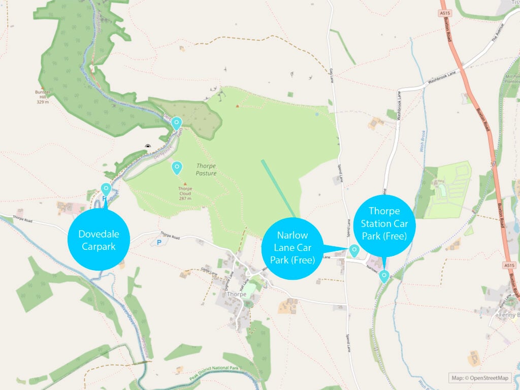
Most visitors arrive at Thorpe Cloud by car. There are three car parks locally which I’ve detailed below and they are all easily accessible. However, at peak times the Dovedale Car Park can get very busy and the final stretch does involve some very narrow roads where you’ll need to use passing spots to let cars going in the other direction pass.
Thorpe Cloud Car Parks
There is no official Thorpe Cloud Car Park as such but there are three local car parks near Thorpe Cloud.
You can see a map of the three local car parks which provide parking for Thorpe Cloud walks in the map above.
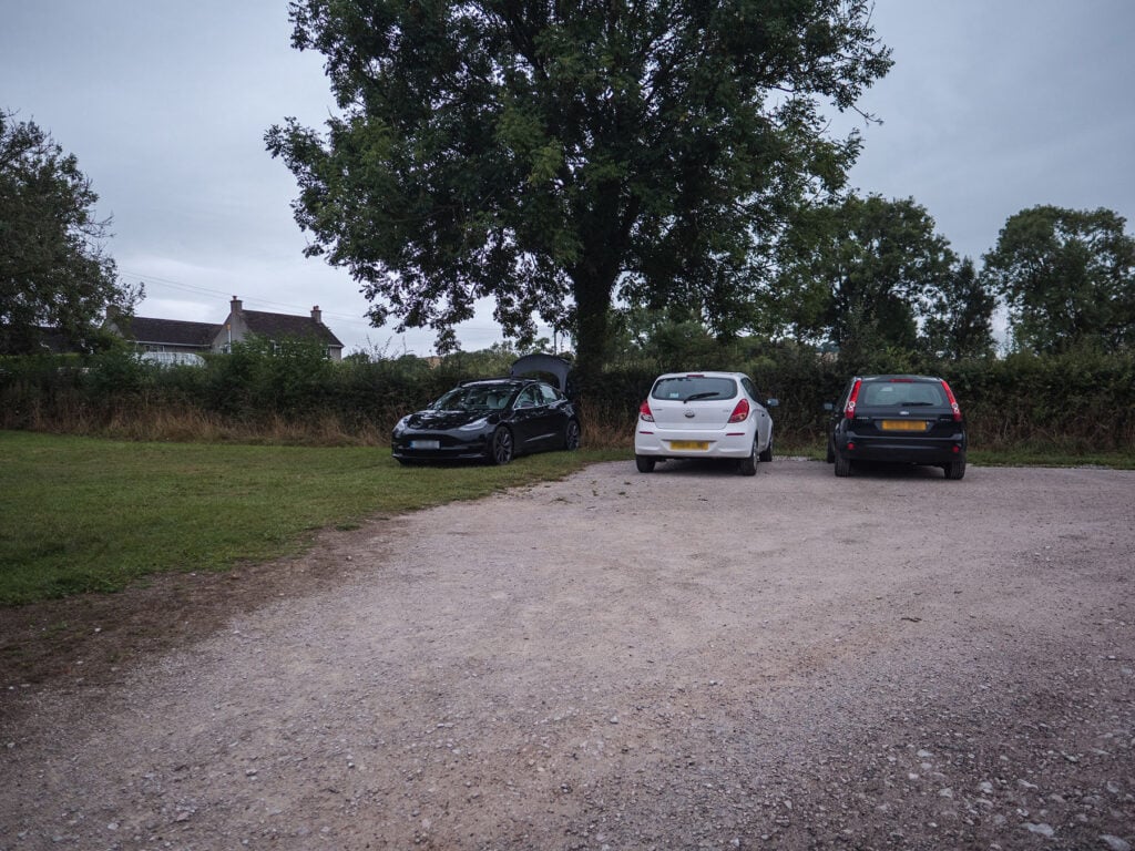
Narlows Lane Car Park and Thorpe Station Car Park
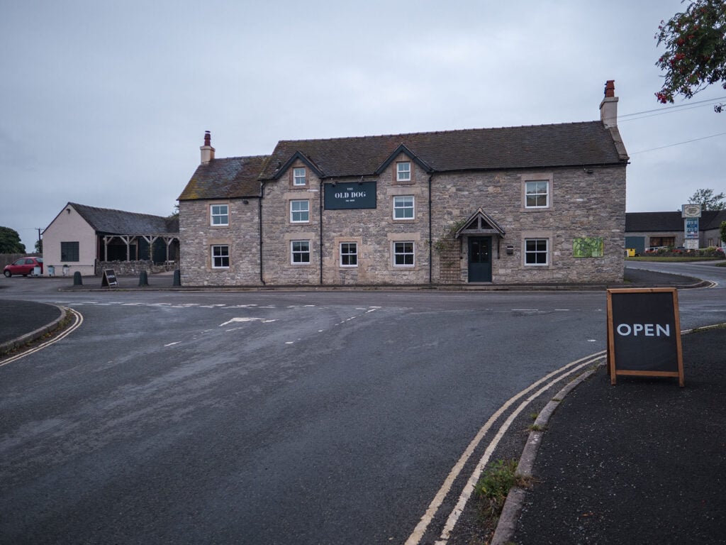
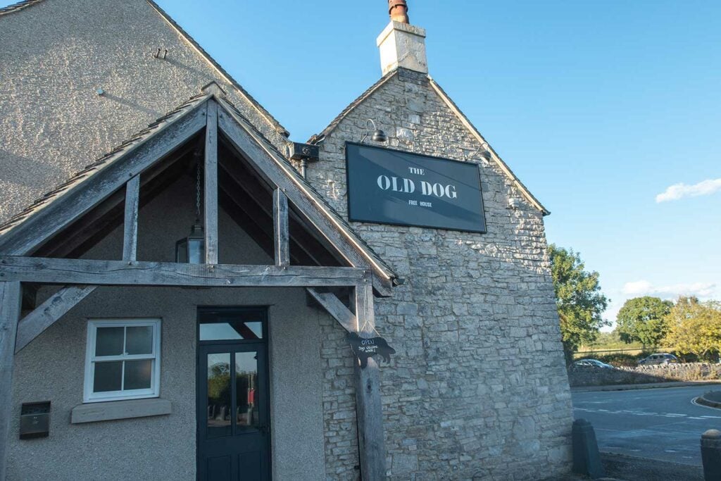
Both with 45 spaces each are free of charge and within a few minutes walk of each other. These car parks are usually my preference as they are typically much quieter than Dovedale car park and free of charge. They are also next to the Old Dog Pub which serves hot food and drinks.
Narlows Lane Car Park and Thorpe Station Car Park are around 0.8 miles by foot from the base of Thorpe Cloud
Opening times: 24/7

Dovedale Car Park
Dovedale Car Park is the primary car park for the Dovedale Stepping Stones and can get really busy at peak times such as school holidays and in the summer. Costs: £4.50 for up to 4 hours and £6 for all day. Machine only takes coins. Free for National Trust Members.
Dovedale car park is around 0.5 miles by foot from the base of Thorpe Cloud. Opening Times: 9am till 7:30pm (I managed to park earlier paying with coins in the machine).
Thorpe Cloud Car Park Postcodes
For Narlows Lane Car Park and Thorpe Station Car Park use postcode: DE6 2AT
For Dovedale Car Park use Postcode DE6 2AY

Getting to Thorpe Cloud by Bus
There are no public transport options which take you directly to the Thorpe Cloud. You can however, take a bus to Ashborn and then walk to Thorpe Cloud. The major bus operators in Ashbourne are Stagecoach Manchester, Trent Barton, and High Peak. View list of bus routes in Ashbourne here.
What is the Best Time of Year to Visit
Thorpe Cloud is not as busy as Dovedale Stepping Stones which gives you a bigger window in which to visit whilst avoiding crowds as long as you use one of the Thorpe Car Parks rather than the Dovedale Car Park.
The perfect time to visit Thorpe Cloud is outside of school holidays and during mild weather. Avoid really hot hot weather as it can get quite tiring hiking the hill and there is no shade. IRain is also best avoided as as it can make the descent quite slippy.
If you’re planning on incorporating Dovedale Stepping Stones into your walk then I’d recommend avoiding weekends and public holidays as well for a more peaceful and authentic experience.
What is the Best Time of Day to Visit
If you’re visiting at a peak time such as school holidays, sunny weekends, public holidays, then arriving before 8am or after 4pm will allow you to avoid the busiest period.
Thorpe Cloud Weather
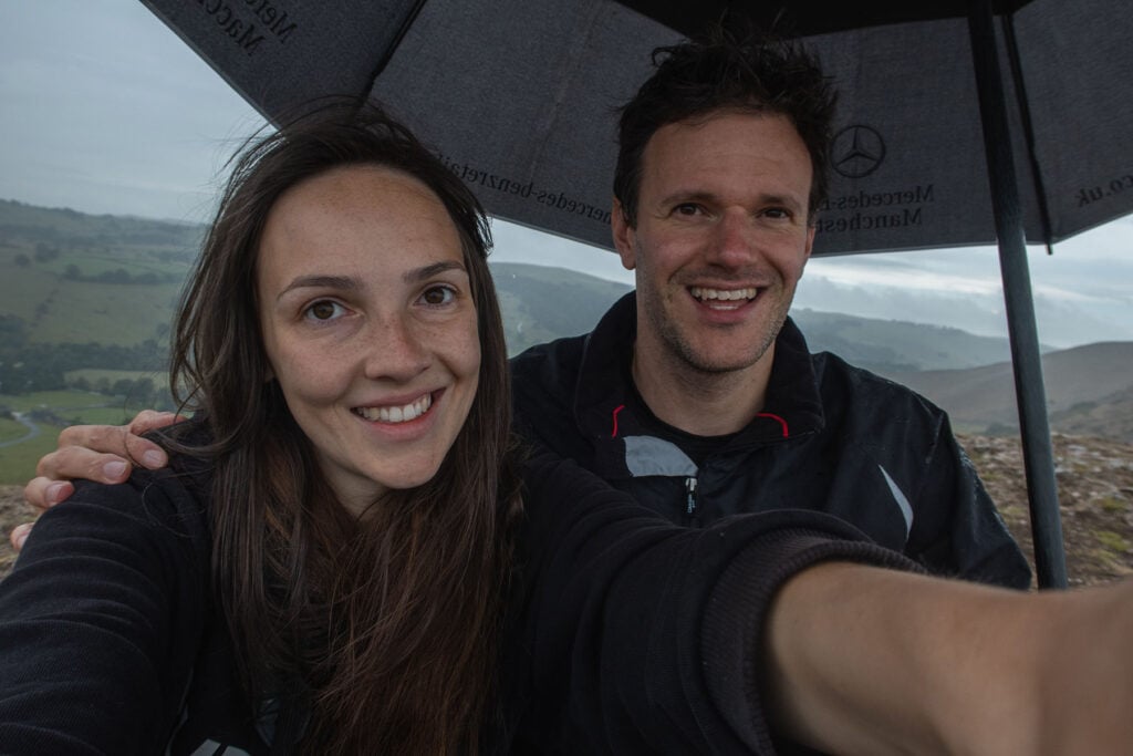
On my first time walking up Thorpe cloud the heavens opened and it was tipping it down by the time I reached the summit. I decided to take an umbrella just in case but with the strong winds I felt like I was going to be blown off the summit when I opened it up.
In the end I sat under the umbrella for around 30 minutes admiring the views until the torrential rain subsided and I was able to hike back down. The rain did make it rather slippery to descend so I’d definitely avoid going when rain is expected in future.
You can see weather forecasts for Thorpe Cloud here and on the met office website for Dovedale here.
Thorpe Cloud Packing list
- Rucksack
- Walking boots with ankle support
- Reusable water bottle – if you venture on the longer walk including Milldale, you can top up water bottles with a drinking water tap outside National Trust toilets.
- Offline maps or physical maps as the signal is non-existent.
- If you’re parking at Dovedale Car Park, loose change (coins) for the parking machine (see rates) and 20p for the toilets.
- Snacks / Picnic
- Camera – Thorpe Cloud and the Dovedale valley is one of the most beautiful in the Peak District with loads of points of interest to photograph.
- Swimwear and microfibre towel if you’re considering a paddle or a swim in the River Dove.
- Torch for exploring the caves if you’re planning to go further down the Dove Valley than the Stepping Stones.
Thorpe Cloud Walks
Located in Derbyshire in one of the most beautiful spots in the UK, Thorpe Cloud can be incorporated into many spectacular walks ranging from an hour to a full day. You can start at Narlows Car Park in Thorpe and simply walk up and down the hill or incorporate the many iconic landmarks in and around the Dovedale Valley including Dovedale Stepping Stones, Bunster Hill, Milldale and Ilam Park.
Thorpe Cloud Walking Routes
The recommended walking routes are changed by the National Trust from time to time to reduce footpath erosion and rock slides. Please follow the signposted routes which may be different to those listed on your map and avoid deviating from the marked footpaths.
Thorpe Cloud Circular Walk Including Dovedale Stepping Stones
This is probably one of my favourite walks of all time because it packs so many great natural wonders and so much enjoyment into a short period of time and there are a couple of food options at the end. Sometimes I extend it to incorporate Milldale and Bunster Hill if I’ve got the whole day to enjoy.
The walk starts off at Thorpe Car Park (it’s quieter than Dovedale, free of charge and is next to a great dining pub). You then hike up Thorpe Cloud walk along the ridge, retract your steps back down the hill and if you fancy it, grab an ice cream or coffee at the Dovedale Car Park. You then stroll over to the Stepping Stones and then head back to Thorpe Car Park where I usually pop into The Dog for a well deserved drink and hot food before driving home.
Thorpe Cloud Circular Walk Map
Route Overview
Walk Type: Circular
Walk Distance: 3.4 miles
Walk Time: 1.5-2 hours
Walk Difficulty: Moderate
Total Ascent: 196m
Highest Point: 262m
Walk Description: A circular route starting in Thorpe and taking you up to the summit of Thorpe Cloud and down again to the Stepping Stones before returning to Thorpe.
Walk Highlights: Thorpe Cloud Summit, Dovedale Stepping Stones.
Terrain Description: A combination of a wide tarmac track, wide gravel tracks, steep ascents on loose earth (to reach Thorpe Clouds’s summit), unpaved and uneven trails through undergrowth and over hills.
Download Maps: GPX Track
Disclaimer: These GPS files are provided free-of-charge for personal use only and may not be uploaded elsewhere. By downloading you acknowledge that walking can be dangerous and this GPS data is provided without any warranty and you absolve this website for any liability.
Stage 1: Narlows Lane Car Park
I usually start this walk from Narlows Lane Car Park for a number of reasons:
- It’s free of charge compared to Dovedale Car park which is £6.
- It’s much quieter than Dovedale Car Park.
- It’s located next to The Dog Pub which gives me the opportunity to have a drink and some food at the end of the walk.
Dovedale Car Park could work for you if you want to shorten the walk or if you’re planning to have a picnic in Dovedale and don’t want to carry everything too far and you’re going at a quiet time.
Stage 2: Walk to The Footpath
Turn right out of the car park and you will see the Old Dog pub straight ahead. Walk down Wintercroft Lane on the right of the pub.
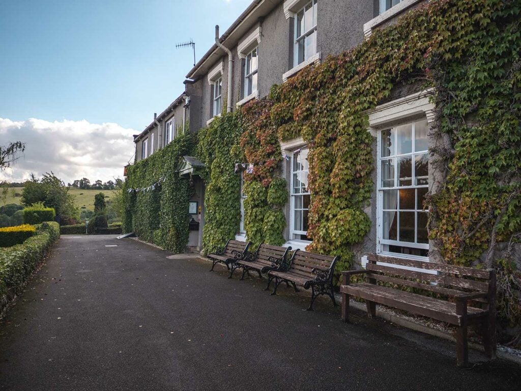
Continue on Wintercroft Lane until you see a large country house straight ahead called Peveril of the Peak Hotel. Just before you enter the gates for the hotel you will see a footpath signpost on the right. Follow this footpath across the field until you reach a small wooden gate.
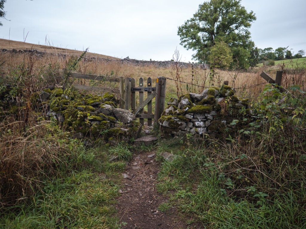
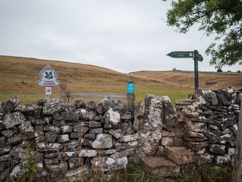
Continue along the footpath and you should see steps over a stone wall and a signpost for Thorpe Pastures.
Stage 3: Cross the Fields to the base of Thorpe Cloud
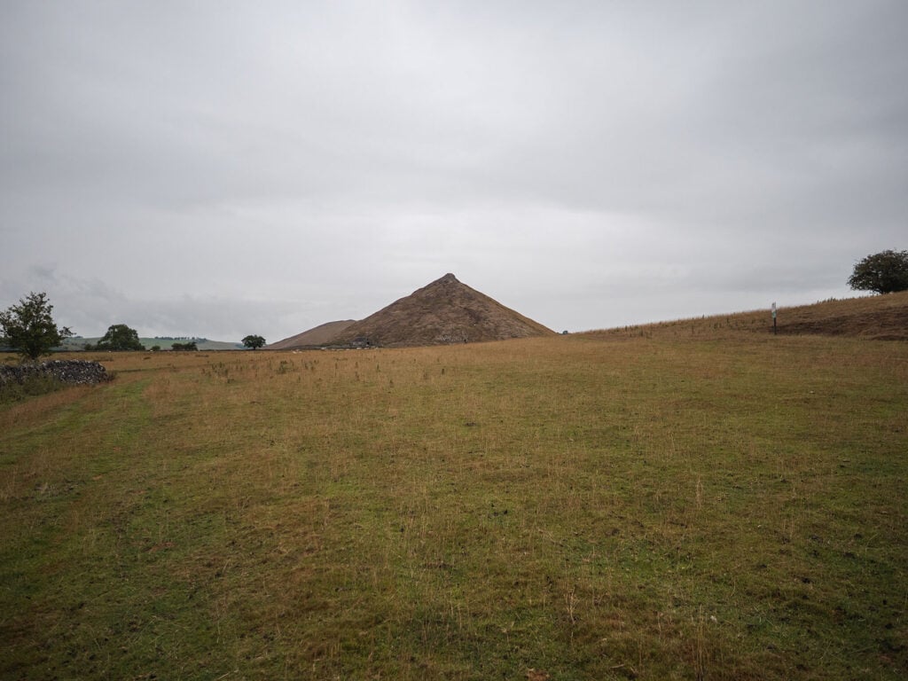
Follow the footpath to the west towards Thorpe Cloud. Take note of the warning signs for the Shooting Range. As the magnificent Thorpe Cloud emerges into view you might catch sight of the tiny dots of people moving up and down the pathway to the summit.
Stage 4: Hike up Thought Cloud and Experience the Amazing Panoramic Views
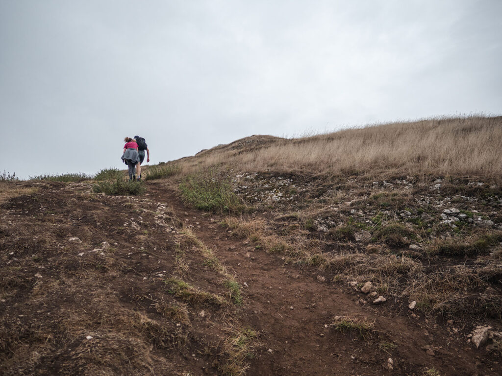
There is a clearly labelled trail up to the top of the hill. These recommended routes change from time to time to avoid erosion. Follow the National Trust signs as maps may not contain the current routes.
It’s a fairly steep gravel path. Make sure to stop on your way up to admire the incredible views being revealed. There is a slight scramble at the end to reach the summit.
To your left you can see Bunster Hill and Ilam Park, to your right Linn Dale. If you walk carefully along the ridge of the submit you can look down onto the famous Dovedale Stepping Stones.

Stage 5: Descend Back Down Thought Cloud and Walk to The River Dove
At the time of writing this, the recommended route back down is the same as the route up. Retrace your steps down the hill being particularly careful if there has been any rain as the descent can get slippy.
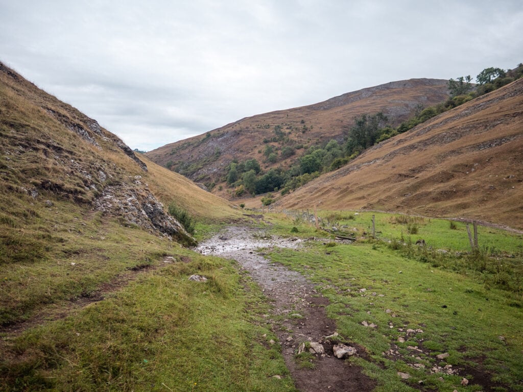
At the base of the hill, head West on either of the two foot paths towards the River Dove.
Cross the small bridge over the River Dove.
Stage 6: Stepping Stones and Ice Cream
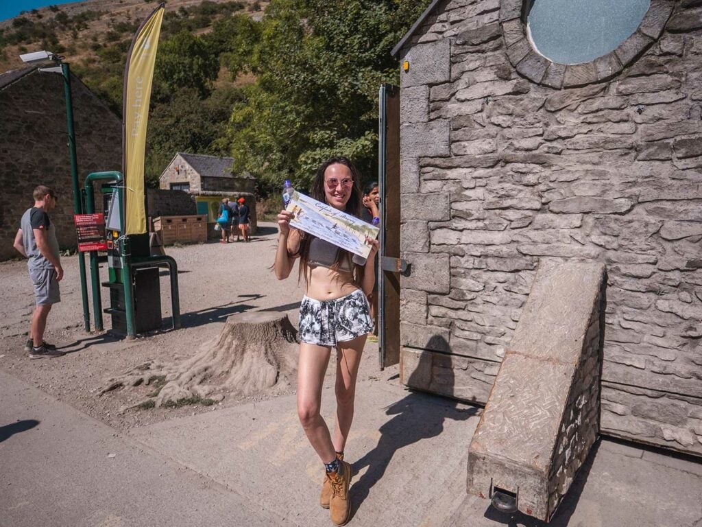
TIP: Fancy ice cream or a drink as a reward for your epic climb? Head left to the Dovedale car park to the refreshments Kiosk. You can also bag yourself a certificate for climbing Thorpe Cloud.
Head right after the bridge down the tarmac path with the River Dove on your right. After about 5-10 minutes you will see the iconic Stepping Stones crossing the river.
Cross the stepping Stones.
Stage 7: Return leg through Lin Dale
Take the second Footpath on the right (the first one will still take you back but the second one is slightly more direct). The foot path takes you along Lin Dale on the east side of Thorpe Cloud
After 10 minutes or so you will see the Pervil of the Peak Hotel again, continue past the hotel and follow the footpath to the south retracing your steps over the stone wall and though the small gate and back down Wintercroft lane to the car park or to the Old Dog pub for a bite to eat or well deserved drink.
It’s cosy inside but can be a little dark for my liking so I usually sit in the large outdoor seating area.

Thorpe Cloud to Milldale Walk including Bunster Hill
This walk gives you a mix of the busier parts of Dovedale whilst also taking you away from the main trail to give you some great views and a different perspective of the valley.
Walk Map
Route Details
Walk Type: Circular
Walk Distance: 7 miles
Walk Time: 3-4 hours
Walk Difficulty: Hard
Total Ascent: 611 m/2,004 ft
Highest Point: 312 m/1,023 ft
Walk Description: A circular walk which will take you up to the summit of Thorpe Cloud before descending into the Dove Valley and walking alongside the River Dove, marvelling at the valley’s limestone structures and caves before crossing the river and ascending the steep hillside until you summit Bunster Hill. From here you will descend and wander through fields before arriving back at the base of Thorpe Cloud.
Walk highlights: Thorpe Cloud Dovedale Stepping Stones, Lovers Leap, The Twelve Apostles, Tissington Spires, Reynards Cave, The Straits, Lion’s Head Rock, Ilam Rock, Bunster Hill
Walk Terrain: A combination of a wide tarmac track, wide gravel tracks, stone steps, steep ascents on loose earth (such as to reach Reynard’s Cave), unpaved and uneven trails through undergrowth and over hills.
Download Maps: GPX Track
Disclaimer: These GPS files are provided free-of-charge for personal use only and may not be uploaded elsewhere. By downloading you acknowledge that walking can be dangerous and this GPS data is provided without any warranty and you absolve this website for any liability.
Click here to view my Thorpe Cloud to Milldale Walk including Bunster Hill walk guide
Ilam to Thorpe Cloud Walk
More information on this walk is coming soon.
FAQs
How Long To Walk Up Thorpe Cloud
The shortest walk from Dovedale car park with a hike up to the summit of Thorpe Cloud and back down again is 2 miles and would take around 1 – 1.5 hours.
The circular walk from Narlows Lane Car Park with a hike up the Thorpe Cloud summit and down again and over to the Stepping Stones before returning to the car park is 3.4 miles and takes 1.5 – 2 hours
How Long Is Thorpe Cloud?
At its longest point Thorpe Cloud’s base is around 700m. The Limestone ridge on the summit is around 100m long.
To hike Thorpe Cloud takes around 1 – 1.5 hours from the carpark.
How High Is Thorpe Cloud in Feet
Thorpe Cloud is Elevation 942 ft high which is 287 m.
Is Thorpe Cloud a Good Place To Bike?
I must admit I’d never considered anyone wanting to ride a bike down Thorpe Cloud. However, you can read a report of someone who gave it a try here. With only one route up the hill currently in use I’d be concerned about the safety of doing this at the current time.
Is Thorpe Cloud Hard To Climb?
Thorpe Cloud is a moderate difficulty to climb. It’s steep but it’s also a relatively short hike. There is a scramble at the very top to reach the summit. On my visits I have seen families with young children enjoying the climb. During wet conditions the climb becomes harder especially the descent as it can become slippy.
Who Owns Thorpe Cloud?
Along with most of Dovedale, Thorpe Cloud and Bunster Hill opposite is owned by the National Trust. The area was acquired by the National Trust in 1934 and forms part of their White Peaks Estate.
Is Thorpe Cloud a Hill or Mountain?
Thorpe cloud with a 942 feet summit is widely considered a hill. However, According to the U.S. Geological Survey, there is no longer an official distinction between hills and mountains.
The United Kingdom and the United States used to define mountains as having a summit over 1,000 feet. However, in the early 1970s both countries abandoned this distinction.
Interestingly I have read in a few places that Thorpe cloud is a “small hill”. However, because of this historical classification it would appear Thorpe Cloud is definitely a large hill and only around 60 feet short of being considered a mountain.
Thorpe Cloud Railway Station
Thorpe Cloud Railway Station was fully closed and the track removed in 1964. The track is now owned by the Peak National park as of 1968 and used as a walking and cycle Route known as the Tissington Trail. Sustrans, A UK-based walking, wheeling and cycling charity purchased The Ashbourne Tunnel at a later date.
What has been Filmed at Thorpe Cloud?
Thorpe Cloud and Dovedale were used as filming locations for the 2010 film of Robin Hood starring Russell Crowe. Thorpe Cloud can be seen in several scenes towards the end of the movie.
‘I would go as far as to say it is breath-taking. We shot some of Robin Hood by the River Dove and it was amazing to see the famous stepping stones. It is all so picturesque. I wanted to take in as much as I could so we travelled around a bit to see more of the area, fantastic.” Russell Crowe taking to the Derbyshire Times.
Food and Drinks Near Thorpe Cloud
The Old Dog (0.85 miles from Thorpe Cloud and 0 miles from the Narlows Lane Car Park and Thorpe Station Car Park)
Local, unfussy, quality food and drinks near Thorpe Cloud. The pub offers both outdoor and indoor seating.
I had a pizza here, it was reasonably priced and tasty. The inside is cosy but the light was a little dark for my liking so I sat at the outside tables in the sun.
Open Wednesdays to Sundays, 3pm – 10pm. Check opening times on their website.
Google reviews: 4.5/5 | My score 4.8/5
National Trust Kiosk (0.6 miles from Thorpe Cloud and 0 miles from Dovedale Car Park)
This kiosk is conveniently located within the Dovedale carpark. It sells a range of snacks from ice cream to sandwiches, teas and coffees to cold drinks.
I’ve not been able to verify opening times but I would imagine it would match the car park opening times of 9am to 7:30pm. May be closed at quiet times of the year.
There’s no seating at the kiosk itself but as you walk from the kiosk towards the Dove Valley you will find walls and tree stumps which you can perch on to enjoy your snacks.
Google reviews: none | My Score: 5/5
For more local cafes, pubs and restaurants view the food and drinks section of my Guide to Dovedale Stepping Stones.
Holiday Cottages Near Thorpe Cloud
Cloud View Cottage
A lovely 3 bed stone cottage to the south of Thorpe Cloud.
Cherry Tree Cottage
Another lovely 3 bed stone cottage to the south of Thorpe Cloud.
Hillcrest House
A beautiful spacious 10 bedroom stone Cottage.
Thorpe Cloud View Holiday Cottage
One bedroom stone cottage with an indoor pool.
Hotels & Hostels Near Thorpe Cloud
The Izaak Walton Country House Hotel
Named after the author of the famous fishing book “The Complete Angler”, this 17th-century hotel features access for trout finishing. It’s just 11 minutes to walk to the Dovedale Car Park or a 3 minute drive.
Google reviews: 4.3 / 5
YHA Ilam Hall Hostel
Cost-effective accommodation within a 17th century gothic manor. Just 25-minutes walk to Dovedale Car Park.
Google reviews: 4.6/5
Thorpe Cloud Camping
Below are the most local campsites to Thorpe Cloud
Common End Farm Campsite – Swinscoe
Google reviews: 4.6 / 5
Thorpe Cloud View Camping – Rowfields
Google reviews: 5/5
Have you been to Thorpe Cloud before? What is your favourite walk?
Ellamckendrick.com is a free online resource. If you have found this website useful for planning your adventures, you can show your support by buying me a coffee. Thanks so much!
